 |

|
Message Board
|
|
 |  | |
 |  | |
 |  | |
 | ||
|
|||||||
| NJFishing.com Fresh Water Fishing Post all your fresh water topics on this board |
 |
|
|
Thread Tools | Display Modes |
|
|
|
#1
 08-14-2016, 09:05 PM
|
||||
|
||||
|
Can anyone tell me how to locate the rivers and streams on Google Earth? I tried to do a google search to explain but still no luck. Thanks in advance

|
|
#2
08-14-2016, 09:21 PM
|
|||
|
|||
|
Why don't you try Bing Maps.
You can alternate between Road, Aerial & Bird's Eye View Maps which will help you locate the water bodies. I frequently use the Bird's Eye to check aerial conditions at places I need site info about before I visit for work. It can give N-S-E & W views of the aerial photos.
|
|
#3
08-14-2016, 09:32 PM
|
||||
|
||||
|
Just use Google maps and change from map to satellite view. You can zoom in pretty close then it'll just to street/ground view
__________________
"There's no losing in fishing. You either catch or you learn."
|
|
#4
08-14-2016, 10:10 PM
|
||||
|
||||
|
Try NJ Geoweb. You can turn on water bodies as a layer and they will stand out much better against the aerial. Link here: http://njwebmap.state.nj.us/NJGeoWeb...68057367877144
__________________
Now the sun is just starting to climb up over the treetops, And it's gonna be a beautiful day, that's plain to see. But I won't be around at all, so don't even bother to call, Cause on a day like today there's one place I gotta be: GONE FISHIN' Fishing with LardAlmighty on YouTube
|
|
#5
08-15-2016, 07:52 AM
|
||||
|
||||
|
Thanks for the help. Good stuff
|
|
#6
08-15-2016, 08:44 AM
|
||||
|
||||
|
If you have a google account you can create a custom google map that will allow you to place markers and add attributes about that spot. You can also group the markers by category (species, kayak/boat/bank, etc)
The awesome thing is that the maps are available on any internet connected device (smartphone, tablet, pc, etc) and within the google maps app on your smartphone. The markers can be exported to KML format for use in Google Earth or other software packages that can read KML Here are some screen shots of what I have done.  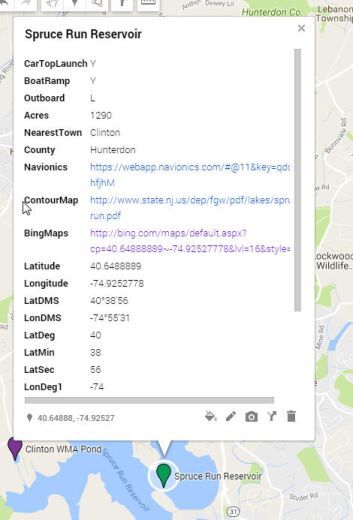 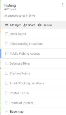
|
|
|
|


 Hybrid Mode
